If a picture is worth a thousand words, then a picture of Acadia a day for 100 days is worth 100,000 words – or maybe 1 million, since we are talking about Acadia National Park.
The official Acadia Centennial logo
Happy 100th Birthday Acadia! We celebrate all the hard work and dedication that led to its founding 100 years ago as Sieur de Monts National Monument on July 8. We appreciate all the efforts today and into the future of those who help to preserve this special place, especially during this Acadia Centennial year.
At the Friends of Acadia annual meeting today at the Bar Harbor Club, big news is expected to be announced to mark the Acadia Centennial. It’s part of the year-long celebration that has included more than 400 Acadia Centennial Partners coming together, including Acadia on My Mind, to plan hundreds of events and help raise funds for the park.
While we won’t be there for that official Centennial celebration, we’ll be commemorating the occasion in our own small way. We’ll hike a trail in Acadia, and get our Passport to the Parks(R) stamped with an Acadia Centennial stamp by our favorite Acadia ranger.

We’ll be getting this stamp in our Passport(R) to Your National Parks from our favorite Acadia Ranger on the actual day of Acadia’s 100th. (Image courtesy Eastern National)
We’ll be working on our Acadia Centennial Partnership projects, like the free year-long virtual 100-mile Acadia Centennial Trek, to celebrate the park and help raise funds for it with an optional finisher’s medal.
Years into the future, we will remember what we were doing on July 8, 2016, the day of the Acadia Centennial. If you don’t happen to be visiting Acadia today or at any other time this year, may this one-a-day-photo-of-Acadia project be our way of sharing this special place with you. We’re not professional photographers, but thankfully Acadia’s beauty makes the picture.
Once we’ve got at least 10 photos up, we’ll start putting them into a slideshow, to make it easier to see the complete album. Bookmark this post to check back on the Acadia Centennial photo album.
We’ll also be posting each new photo on our Facebook page. And feel free to share your own favorite photos of Acadia on our Facebook page as well. Many of these photos have been featured in our Hiking Acadia National Park guide published by Falcon.
Happy 100th Birthday, Acadia!
Acadia slideshow – 100 photos, 1 a day – click on last dot to see latest


Here are the pictures of Acadia displayed one by one, newest at top:
Day 100 – Bass Harbor Head Light

The only lighthouse in Acadia National Park, Bass Harbor Head Light is picture postcard perfect. President Obama and his family got a special tour of the lighthouse when they vacationed in Acadia in July 2010.
Day 99 – Ship Harbor Trail

Sail on by Ship Harbor.
Day 98 – Wonders of Wonderland

Low tide exposes kelp, snails and other wonders of the intertidal zone along Wonderland.
Day 97 – West Ledge Trail

There’s solitude at sunset on the West Ledge Trail of Bernard Mountain.
Day 96 – Razorback Trail

Looking north toward the mainland from the Razorback Trail.
Day 95 – Perpendicular Trail

About 500 stone steps take you up the Perpendicular Trail.
Day 94 – Long Pond Trail

The Civilian Conservation Corps built this trail along Long Pond.
Day 93 – Beech West Ridge Trail

Looking north along Long Pond from Beech West Ridge Trail, the steepest way up Beech Mountain.
Day 92 – Valley Trail

The lush Valley Trail features ferns growing atop house-size boulders. The trail allows for a loop to Long Pond and up Beech Mountain.
Day 91 – Beech Mountain Loop

Long Pond dominates the view from the western section of the Beech Mountain Loop, where migrating raptors can often be seen.
Day 90 – Beech Cliff

Beech Cliff overlooks Echo Lake.
Day 89 – Valley Cove Trail

Valley Cove Trail is often closed during peregrine falcon nesting season, and is currently closed for trail maintenance.
Day 88 – Valley Peak

Greening Island and Southwest Harbor are visible from Valley Peak
Day 87 – Somes Sound, formerly known as a fjord

From Acadia Mountain, you can see the mouth of Somes Sound, formerly known as a fjord, and now more properly called a fjard, according to geologists. A new park wayside exhibit on Sargent Drive, across from Acadia Mountain, uses the proper term. A fjard is shallower, shorter and broader than a fjord.
Day 86 – Lower Hadlock Pond

The views from Lower Hadlock Pond toward Bald Peak rival those from Jordan Pond toward the Bubbles.
Day 85 – Goat Trail

These log stairs on the Goat Trail make the climb up Norumbega Mountain a little less strenuous.
Day 84 – Parkman Mountain and Bald Peak Trails

Rosa rugosa and Bald Peak in the background, a view on the way from Parkman Mountain.
Day 83 – Hadlock Brook Trail

Waterfall Bridge, as seen from the Hadlock Brook Trail.
Day 82 – Amphitheater Trail

Stepping stones take you under the Amphitheater Bridge, along the Amphitheater Trail.
Day 81 – Sargent South Ridge Trail

Sargent South Ridge Trail ablaze in pink with rhodora abloom, usually in late May, early June.
Day 80 – Giant Slide Trail

The Giant Slide Trail has you climbing under and over tricky spots, like this one. Don’t bump your head on the rock overhang.
Day 79 – Sargent East Cliffs Trail

Bates cairns lead the way along Sargent East Cliffs Trail, toward the view of Pemetic and Cadillac Mountains.
Day 78 – Deer Brook Trail

The year of construction, 1925, is set into the circular medallion of the Deer Brook Bridge.
Day 77 – Jordan Cliffs Trail

Jordan Cliffs Trail is where this unique balance-beam-like structure can be found.
Day 76 – Mansell overlook

A cryptic circle of blue blazes marks the Mansell overlook, with a view of the Beech Mountain firetower across the way.
Day 75 – Penobscot Mountain Trail

Look down upon the Bubbles and Jordan Pond from the Penobscot Mountain Trail. Below this ridge is the Jordan Cliffs Trail, often closed during peregrine falcon nesting season.
Day 74 – Spring Trail

On the way to Penobscot, along the Spring Trail, a perfectly placed stone bench to take in the view of Jordan Pond, South Bubble and Pemetic.
Day 73 – Jordan Pond Carry

Eagle Lake as seen from the intersection of Jordan Pond Carry and the Eagle Lake Trail.
Day 72 – Bubbles Trail

From South Bubble, the view of Jordan Pond and the Cranberry Isles takes your breath away.
Day 71 – Asticou & Jordan Pond Path

Along the Asticou & Jordan Pond Path, evidence of pileated woodpecker activity.
Day 70 – Cobblestone Bridge

Cobblestone Bridge is a popular stop for the horse-drawn carriage rides of Acadia, but it can also be reached by a short hike from the Jordan Pond House, along the Jordan Stream Trail or the carriage roads.
Day 69 – Jordan Pond

Jordan Pond with a view of the Bubbles, a classic Acadia scene.
Day 68 – LIttle Hunters Beach

Little Hunters Beach features this series of cascades, accessed by a set of stairs from the Park Loop Road.
Day 67 – Hunters Beach Trail

Colorful sea cliffs at Hunters Beach, accessed by a short easy trail off Cooksey Drive.
Day 66 – Hunters Brook Trail

The less-traveled Hunters Brook Trail is home to the elusive Spruce grouse.
Day 65 – On the way to the Triad

A Bates cairn on the trail to the Triad.
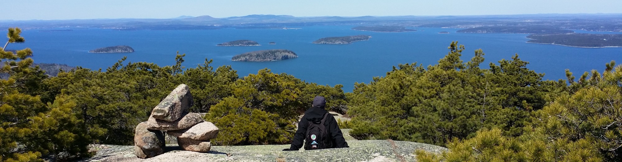
Day 64 – Pemetic

From Pemetic’s ridge, you can see clear to the mainland.
Day 63 – Pemetic Northwest Trail

Along the Pemetic Northwest Trail, hiker’s choice: Ledge or ravine?
Day 62 – Bubble Pond

Bubble Pond is the starting point for the Cadillac West Face Trail, the hardest way up Acadia’s tallest peak, and the Pemetic North Ridge Trail.
Day 61 – Cadillac South Ridge Trail

Supermoon reflected in Frenchman Bay, as seen along the Cadillac South Ridge Trail.
Day 60 – Gorge Path

The recently rehabilitated Gorge Path takes you up the gap between Cadillac and Dorr Mountains
Day 59 – Cadillac Summit Loop

Along the Cadillac Summit Loop, you can find this memorial plaque to wealthy businessman and conservationist Stephen Tyng Mather, who helped push for the founding of the National Park Service in 1916, and became its first director.
Day 58 – Cadillac North Ridge Trail

HawkWatch takes place late summer into mid-fall just a short distance from this view on the Cadillac North Ridge Trail.
Day 57 – Jesup Path

In springtime in Acadia, apple blossoms frame the view of Huguenot Head and Great Meadow from Jesup Path.
Day 56 – Hemlock Path

Hemlock Path makes for a pleasant woods walk. The well-graded trail near Sieur de Monts allows for many loop possibilities, up Kebo or Dorr Mountains, or along Great Meadow.
Day 55 – A. Murray Young Path

The sound of cascades and birdsong may be the only thing breaking the silence along the A. Murray Young Path. It’s a less-traveled trail to the gorge between Cadillac and Dorr.
Day 54 – Canon Brook Trail

This section of the Canon Brook Trail, just west of the mountain pond known as the Featherbed, looks a bit like Zion.
Day 53 – Ladder Trail

Near the top of the Ladder Trail is this boulder that rivals Bubble Rock in stature.
Day 52 – Kane Path

You can reach Kane Path by stepping across the outlet of the Tarn, along the pink granite rocks set perfectly flat.
Day 51 – Kurt Diederich’s Climb

From Kurt Diederich’s Climb, you get this view of Huguenot Head.
Day 50 – Emery Path

Sun filtering through the trees casts a soft light on the stone steps of Emery Path.
Day 49 – Homans Path

From Homans Path, you get an expansive view of Great Meadow and the Porcupine Islands, as you head up the side of Dorr Mountain.
Day 48 – Kebo Mountain

Views are limited at the top of Kebo Mountain, but you still feel up close and personal with the Porcupine Islands. For some reason, Kebo is not on the list of 26 Acadia peaks that the park used to have on its Web site.
Day 47 – Otter Cove

Otter Cove, once a busy waterfront for the village of Otter Creek, is now where Acadia National Park’s Quarry and Otter Cove Trails meet.
Day 46 – Gorham Mountain and Cadillac Cliffs Trails

At the junction of Gorham Mountain and Cadillac Cliffs Trails, this memorial plaque to Waldron Bates can be found. Chair of the Roads and Paths Committee of the Bar Harbor Village Improvement Association from 1900 to 1909, Bates developed a style of cairn, or stone trail marker, that’s still used on many Acadia trails.
Day 45 – The Beehive Trail

The Beehive Trail is not for the faint of heart, with iron rungs taking you up the nearly vertical rock face.
Day 44 – The Bowl Trail

The evening sky glows pink above the Bowl, a mountain pond northwest of the Beehive.
Day 43 – Ocean Path

A plaque marking John D. Rockefeller Jr.’s contributions to Acadia National Park is located on a rockface not too far from this spot on Ocean Path.
Day 42 – Sand Beach and Great Head

Fog lifts to reveal the wonder of Sand Beach and Beehive, as seen from the Great Head Trail. The ruins of a tea house can be seen on Great Head.
Day 41 – Schooner Head Overlook

Recent restoration of the historic vista at Schooner Head Overlook opens up the view to Egg Rock and its lighthouse, across Frenchman Bay to Schoodic Peninsula.
Day 40 – Precipice Trail

Climbng more than 900 feet in less than a mile, the Precipice Trail is not for the faint of heart, out of shape or people afraid of heights.
Day 39 – Orange & Black Path

A hiker ascends Orange & Black Path. A century ago, trailblazer and Princeton professor Rudolph E. Brunnow named the path after his school’s colors.
Day 38 – Champlain South Ridge Trail

The views from the Champlain South Ridge Trail are toward Sand Beach, Beehive and Otter Cliff with Baker Island in distance.
Day 37 – Beachcroft Path

Beachcroft Path is garden-like with its stepping stones.
Day 36 – Compass Harbor Trail – Acadia on My Mind YouTube channel
Day 35 – Bar Island Trail

Only at low tide can you walk across the sand bar to Bar Island. It’s safe up to 1-1/2 to 2 hours on either side of the tide; otherwise you risk getting stranded.
Day 34 – Goat Trail on Isle au Haut

The contrasts are dramatic along the Goat Trail on Isle au Haut. There’s another Goat Trail in Acadia, up Norumbega Mountain, but it doesn’t offer the same contrast between white volcanic rock, pink granite, evergreens and deep blue sea as this version.
Day 33 – Eben’s Head on Isle au Haut

Eben’s Head, a rocky promontory, can easily be climbed and is great for watching a sunset on Isle au Haut.
Day 32 – Bowditch Mountain on Isle au Haut

On the other side of this field of ferns is wooded Bowditch Mountain, on Isle au Haut, the most remote part of Acadia National Park, reachable only by mailboat.
Day 31 – Duck Harbor Mountain, on Isle au Haut

Duck Harbor Mountain is on Isle au Haut, the most remote part of Acadia, reachable only by mailboat. Strange rocky knobs known as the Puddings can be found on its south ridge.
Day 30 – Spruce grouse on Buck Cove Mountain Trail

Spruce grouse on Buck Cove Mountain Trail, which leads from Schoodic Woods Campground to Schoodic Head.
Day 29 – Blueberry Hill, on Schoodic

Blueberry Hill offers fine ocean views from the Schoodic Peninsula in Acadia National Park. The Alder Trail, which leads to the Schoodic Head Trail, starts across from the Blueberry Hill parking lot, off the one-way Schoodic Park Loop Road.
Day 28 – Sundew Trail, on Schoodic Peninsula

Sundew Trail offers spectacular views, seaside benches and solitude. Located on the Schoodic Education and Research Center campus and featured in our book, “Hiking Acadia National Park.”
Day 27 – Schoodic Head, on the mainland section of Acadia

The view from Schoodic Head, elevation 440 feet, in the only part of Acadia on the mainland. A network of trails leads to the top, some starting at the 1-way Park Loop Road, and 1 from the new Schoodic Woods Campground.
Day 26 – Bird’s eye view from Flying Mountain

From Flying Mountain, you can see the mouth of Somes Sound and the Cranberry Isles. It’s the lowest of 26 peaks on Mount Desert Island, at 284 feet.
Day 25 – The Beehive

Early morning is the best time to hike the Beehive Trail if you want to avoid the crowds in summer. It’s a most difficult trail, so hike it only if you are well-prepared, not afraid of heights and comfortable climbing a nearly vertical trail featuring iron rungs.
Day 24 – Gorham Mountain, on the closest ridge to Frenchman Bay

On the closest mountain ridge to Frenchman Bay, Gorham offers breathtaking views, south to Otter Cliff, Baker Island and beyond. At 525 feet, it is the 24th highest peak on Mount Desert Island.
Day 23 – Day Mountain, the only summit with a carriage road

The only summit with a carriage road up to the top, Day Mountain offers the closest views of the Cranberry Isles. You may also find passengers on a horse-drawn carriage or bicyclists at the peak.
Day 22 – St. Sauveur Mountain has limited views, but it’s no dog

On the way to St. Sauveur Mountain, and even atop the summit, there are limited views. Formerly known as Dog Mountain, it is the 22nd highest peak on Mount Desert Island.
Day 21 – Youngs Mountain, where there are no maintained trails

Youngs Mountain in Acadia National Park is the 21st highest peak on Mount Desert Island. Without maintained trails, the summit can only be reached by experienced hikers who know how to bushwhack, use a map and compass or GPS -or by the infrequent and elusive moose.
Day 20 – Acadia Mountain, with a view of Somes Sound

From the peak of Acadia Mountain, hikers can see Somes Sound and the Cranberry Islands. Acadia is the park’s only mountain on an east-west ridge.
Day 19 – The Triad

You can often find solitude at The Triad. On the same ridge as Pemetic and Day Mountains, it’s 698 feet and the 19th highest peak on Mount Desert Island.
Day 18 – McFarland Mountain provides a different perspective

Looking south from McFarland Mountain, a view toward Eagle Lake, with Cadillac on the left, Pemetic in the middle and the Bubbles on the right. There isn’t a maintained trail to the 724-foot mountain, although McFarland is near the park headquarters.
Day 17 – On the way to Huguenot Head, 17th highest peak on MDI

On the way to Huguenot Head, 731 feet elevation, you’ll pass this distinctive rock on Beachcroft Path. There’s an historic photo of George B. Dorr standing by this very same rock.
Day 16 – South Bubble, home of Bubble Rock

Atop South Bubble, you can see the higher North Bubble looming beyond. If you look to the south beyond Jordan Pond, you’ll see the glacial moraine that Jordan Pond House sits on. And just northeast of the summit off a spur trail, perches the famous Bubble Rock.
Day 15 – Beech Mountain features Acadia’s only fire tower

The only fire tower in Acadia National Park is on top of Beech Mountain, the 15th highest peak on Mount Desert Island at 839 feet. You can only get to the top platform during a fire tower open house.
Day 14 – Norumbega overlooking Somes Sound, Acadia Mountain

The view from Norumbega, the 14th highest peak on Mount Desert Island at 852 feet, includes Somes Sound, Acadia Mountain and beyond.
Day 13 – North Bubble, the taller of the twin peaks along Jordan Pond

A view of Jordan Pond rom the taller of the twin mountains known as the Bubbles. At 872 feet, North Bubble is the 13th highest peak on Mount Desert Island.
Day 12 – Parkman Mountain with a view toward Bald Peak

Parkman, at 941 feet, is a tad shorter than Balk Peak, as seen in the distance.
Day 11 – Cedar Swamp Mountain, 11th highest peak on MDI

A spur off Sargent Mountain South Ridge Trail, Cedar Swamp is off the beaten path.
Day 10 – Overlook near Mansell, 10th highest peak on MDI

Mansell of Western Mountain is a wooded summit, but there is this nearby viewpoint looking down on Long Pond and beyond.
Day 9 – Bald Peak, 9th highest on Mount Desert Island at 974 feet

Bald Peak looks over Upper and Lower Hadlock Ponds and beyond.
Day 8 – Gilmore Peak, in the shadow of Sargent, east of Parkman

Gilmore Peak is less visited than neighboring Bald, Parkman and Sargent mountains. At 1,036 feet, it is the 8th highest peak on Mount Desert Island.
Day 7 – Champlain Mountain, overlooking Frenchman Bay

A Bates-style cairn, located on the Champlain North Ridge Trail, overlooks tiny Egg Rock with its lighthouse, and the Schoodic Peninsula. Don’t be tempted to add to or take away from the historic trail markers, or randomly pile rocks yourself. That would be contrary to Leave No Trace(R) principles amd park rules. Champlain, the 7th highest peak in Acadia, is at the top of the Precipice Trail.
Day 6 – Limited views, plenty of solitude on Bernard Mountain

The overlook is grown in at Bernard, the sixth highest peak in Acadia at 1,071 feet, and part of what’s known as Western Mountain.
Day 5 – View from Penobscot, 5th highest peak in Acadia

Eagle Lake can be seen in the distance, looking northeast from Penobscot Mountain.
Day 4 – From Pemetic, you can see forever

The 4th highest mountain in Acadia at 1,248 feet, Pemetic provides a spectacular view of the Cranberry Isles and beyond from its south ridge. We like this photo so much, we picked it for the cover of the 3rd edition of our book, “Hiking Acadia National Park.”
Day 3 – Dorr Mountain, 3rd highest, named after “father of Acadia”

Atop Dorr Mountain, you can see the Porcupine Islands, and examples of the historic Bates-style cairn, a stone trail marker unique to Acadia. Do not add to or take away from the cairns, or pile rocks randomly yourself. That would violate the Leave No Trace(R) principles that help protect the park, and wreak havoc for other hikers and trail crew.
Day 2 – Pretty in pink, rhodora on Sargent, Acadia’s 2nd highest peak

In late May, early June, the pink blooms of rhodora complement the pink granite of Sargent, the 2nd highest peak in Acadia.
Day 1 – To celebrate the Acadia Centennial, rainbow beyond Cadillac

Day 1 – To celebrate the Acadia Centennial, rainbow beyond Cadillac – You may have seen a sunrise from Cadillac, but have you seen a rainbow? Of all the visitors on Cadillac this day in May 2014, we were the first to spot the rainbow across Frenchman Bay. It started as a double rainbow.
Pingback: Baker Island resident authors first history of Acadia island
Great photos. This has given me more ideas for so many hikes to take. It will take the rest of my life time to take them all! Thanks.
Hi Jeanette, glad you like the photos! Can’t ever have too many reasons to visit Acadia. And if you have Acadia on your mind, as we do, you might want to check out this new virtual race we’re co-sponsoring, called the Cadillac to Katahdin Virtual Run: https://acadiaonmymind.com/2017/08/acadia-millinocket-fans-join-forces-for-virtual-race-2017/
Pingback: Physically disabled persons praise, question access to Acadia
Pingback: Photographer's 'Enchanted Forest' to grace Acadia park pass
Pingback: Give the gift of art or photos of Acadia for the holidays
Pingback: New Acadia National Park hiking group open to all
Beautiful photography. I hope you’re planning on doing the mountain at Schoodic and Isle au Haut. Thank you for sharing – I’m looking forward to the remaining photographs.
Thanks for the comment, Alice. Yes, we will definitely include photos of Schoodic Head and mountains on Isle au Haut, maybe the spectacular Duck Harbor Mountain. We just hiked the beautiful Sundew Trail on Schoodic in July and had a great couple of days of hiking last year on Isle au Haut.
Pingback: History and tales of adventures in Acadia run through Orono